SUBHEAD: Built by the USA this 350 foor wide dome in the Pacific houses tons of radioactive waste – and it's leaking.
By Coleen Jose & Kim Wall on 3 July 2015 for the Guardian -
(http://www.theguardian.com/world/2015/jul/03/runit-dome-pacific-radioactive-waste)
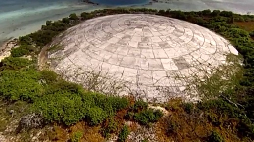
Image above: The Runit Dome on Enewetak atoll stores plutonium. A still frame from video below.
The Runit Dome in the Marshall Islands is a hulking legacy of years of US nuclear testing. Now locals and scientists are warning that rising sea levels caused by climate change could cause 111,000 cubic yards of debris to spill into the ocean.
Black seabirds circle high above the giant concrete dome that rises from a tangle of green vines just a few paces from the lapping waves of the Pacific. Half buried in the sand, the vast structure looks like a downed UFO.
At the summit, figures carved into the weathered concrete state only the year of construction: 1979. Officially, this vast structure is known as the Runit Dome. Locals call it The Tomb.
Below the 18-inch concrete cap rests the United States’ cold war legacy to this remote corner of the Pacific Ocean: 111,000 cubic yards of radioactive debris left behind after 12 years of nuclear tests.
Brackish water pools around the edge of the dome, where sections of concrete have started to crack away. Underground, radioactive waste has already started to leach out of the crater: according to a 2013 report by the US Department of Energy, soil around the dome is already more contaminated than its contents.
Now locals, scientists and environmental activists fear that a storm surge, typhoon or other cataclysmic event brought on by climate change could tear the concrete mantel wide open, releasing its contents into the Pacific Ocean.
“Runit Dome represents a tragic confluence of nuclear testing and climate change,” said Michael Gerrard, director of the Sabin Center for Climate Change Law at Columbia University, who visited the dome in 2010.
“It resulted from US nuclear testing and the leaving behind of large quantities of plutonium,” he said. “Now it has been gradually submerged as result of sea level rise from greenhouse gas emissions by industrial countries led by the United States.”
Enewetak Atoll, and the much better-known Bikini Atoll, were the main sites of the United States Pacific Proving Grounds, the setting for dozens of atomic explosions during the early years of the cold war.
The remote islands – roughly halfway between Australia and Hawaii – were deemed sufficiently distant from major population centres and shipping lanes, and in 1948, the local population of Micronesian fishermen and subsistence farmers were evacuated to another atoll 200 km away.
In total, 67 nuclear and atmospheric bombs were detonated on Enewetak and Bikini between 1946 and 1958 – an explosive yield equivalent to 1.6 Hiroshima bombs detonated every day over the course of 12 years.
The detonations blanketed the islands with irradiated debris, including Plutonium-239, the fissile isotope used in nuclear warheads, which has a half-life of 24,000 years.
Video above: Video of visit to Runit Dome. From original article.
[IB Publisher's note: We found this link (http://pruned.blogspot.com/2009/03/concrete-domed-radioactive-landfill-of.html). "According to the Brookings Institution, “beneath this concrete dome on Runit Island, part of Enewetak Atoll, built between 1977 and 1980 at a cost of about $239 million, lie 111,000 cubic yards or radioactive soil and debris from Bikini and Rongelap atolls. The dome covers the 30-foot deep, 350-foot wide crater created by the May 5, 1958, Cactus nuclear weapon test.” Photo by the Defense Special Weapons Agency. Thanks, Capability B., for the link."]
.
By Coleen Jose & Kim Wall on 3 July 2015 for the Guardian -
(http://www.theguardian.com/world/2015/jul/03/runit-dome-pacific-radioactive-waste)
Image above: The Runit Dome on Enewetak atoll stores plutonium. A still frame from video below.
The Runit Dome in the Marshall Islands is a hulking legacy of years of US nuclear testing. Now locals and scientists are warning that rising sea levels caused by climate change could cause 111,000 cubic yards of debris to spill into the ocean.
Black seabirds circle high above the giant concrete dome that rises from a tangle of green vines just a few paces from the lapping waves of the Pacific. Half buried in the sand, the vast structure looks like a downed UFO.
At the summit, figures carved into the weathered concrete state only the year of construction: 1979. Officially, this vast structure is known as the Runit Dome. Locals call it The Tomb.
Below the 18-inch concrete cap rests the United States’ cold war legacy to this remote corner of the Pacific Ocean: 111,000 cubic yards of radioactive debris left behind after 12 years of nuclear tests.
Brackish water pools around the edge of the dome, where sections of concrete have started to crack away. Underground, radioactive waste has already started to leach out of the crater: according to a 2013 report by the US Department of Energy, soil around the dome is already more contaminated than its contents.
Now locals, scientists and environmental activists fear that a storm surge, typhoon or other cataclysmic event brought on by climate change could tear the concrete mantel wide open, releasing its contents into the Pacific Ocean.
“Runit Dome represents a tragic confluence of nuclear testing and climate change,” said Michael Gerrard, director of the Sabin Center for Climate Change Law at Columbia University, who visited the dome in 2010.
“It resulted from US nuclear testing and the leaving behind of large quantities of plutonium,” he said. “Now it has been gradually submerged as result of sea level rise from greenhouse gas emissions by industrial countries led by the United States.”
Enewetak Atoll, and the much better-known Bikini Atoll, were the main sites of the United States Pacific Proving Grounds, the setting for dozens of atomic explosions during the early years of the cold war.
The remote islands – roughly halfway between Australia and Hawaii – were deemed sufficiently distant from major population centres and shipping lanes, and in 1948, the local population of Micronesian fishermen and subsistence farmers were evacuated to another atoll 200 km away.
In total, 67 nuclear and atmospheric bombs were detonated on Enewetak and Bikini between 1946 and 1958 – an explosive yield equivalent to 1.6 Hiroshima bombs detonated every day over the course of 12 years.
The detonations blanketed the islands with irradiated debris, including Plutonium-239, the fissile isotope used in nuclear warheads, which has a half-life of 24,000 years.
Video above: Video of visit to Runit Dome. From original article.
[IB Publisher's note: We found this link (http://pruned.blogspot.com/2009/03/concrete-domed-radioactive-landfill-of.html). "According to the Brookings Institution, “beneath this concrete dome on Runit Island, part of Enewetak Atoll, built between 1977 and 1980 at a cost of about $239 million, lie 111,000 cubic yards or radioactive soil and debris from Bikini and Rongelap atolls. The dome covers the 30-foot deep, 350-foot wide crater created by the May 5, 1958, Cactus nuclear weapon test.” Photo by the Defense Special Weapons Agency. Thanks, Capability B., for the link."]
.
No comments :
Post a Comment